|
Saltford Environment Group
|
|
SEG Home > History of Saltford > A - Z > Walks of Saltford > Walk 3 Walk 3 - Longwood and a Roman dwelling siteThis easy walk explores the southern slopes above Saltford, with a pleasant walk through a wood and then a downhill walk through fields with wonderful views to the north. The walk takes you through the heart of an area which was almost certainly inhabited by the Romans. You return through the many hidden footpaths that link the residential areas south of the A4.
|
Download the pdf version here
|

Map © OpenStreetMap contributors http://www.openstreetmap.org/copyright
|
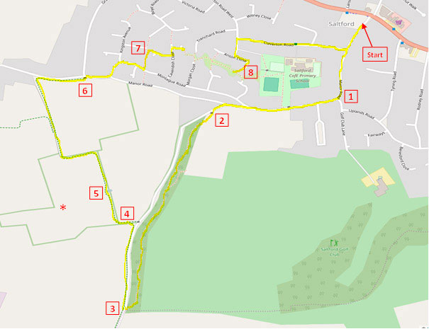
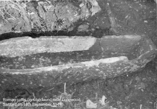
Walk up Manor Road, and follow it round to the right (1). Manor Road was originally called Burnett Road (going up what we now call Longwood Lane, it was the shortest route to Burnett). In 1928 it became Burnett Lane, and then at a later stage became Manor Road, named after Keynsham Manor, which it passes. It is 2 miles in length, leading right through to the Wellsway in Keynsham. Until the late 1920s this was a country lane, with only on small cottage (roughly opposite Claverton Road today). Most of the other houses on Manor Road were built in the 1930s. In the nineteenth century Golf Club Lane was known as Pig's Path, and it led up to a large, long field of the same name - now part of the golf course. Follow the road, and when you come to the 'Manor Lawns' sign, take the left fork, and turn left after 50m or so up Longwood Lane (no road name sign). Almost immediately turn into a gateway on your left labelled 'Saltford Golf Club Private No Parking (2)', and follow the path round the gate and into the wood. Longwood is not shown on the Tithe Map of 1837 - the first detailed map of the area - but is on the first Ordnance Survey map of c.1880. Back then, Longwood Lane, that runs along the wood, marked the boundary between the parishes of Saltford and Keynsham. Today this boundary lies further to the west. Walk up through the wood, crossing the golf course access track on the way. Eventually the footpath brings you out onto Longwood Lane again. Cross straight over into the field and turn immediately right (3). If you look across the field you are now in, you can see Burnett Business Park on the horizon. This seems an odd place for a business park, but its origins go back to the Second World War, when a munitions dump was located there. This footpath is a Permissive Path, a path whose use is allowed by the landowner. The Permissive Paths to the south and west of Saltford were closed in 2013 following the withdrawal of subsidies for public access by DEFRA. The Saltford Community Association has worked with the local farmer and have signed a legal agreement allowing access to 4.5Km of these paths. In order for these paths to remain open the SCA needs to raise specific donations of £3000 every year. You can make a donation by contacting the SCA at Saltford Hall (www.saltfordhall.co.uk). As you walk down this path there are magnificent views to the north (height of crops permitting!). Far over to your left you can make out the tops of the support towers of the Clifton Suspension Bridge, whilst over to your right opposite is the village of Upton Cheney. Keep on until the end of the field where the path swings round to the left, and then move into the next field down at the opening (4). Turn left here - i.e. walk away from the road - into the next field and turn immediately right with the hedgerow on your right. After a little way you pass a clump of trees on your right which surround a stone-lined pond (5). This pond is of unknown date, but it has been carefully constructed and was no doubt used to provide water for cattle; there is an easy slope down to the water on either side. Importantly, it indicates some sort of a spring and a ready source of water. Just over to your left, and marked with a star on the map of this walk, a Roman stone coffin was found in 1948 by a farmer digging up an old tree stump. The coffin contained a skeleton. In the vicinity oyster shells and pottery shards have been found, and in 1948 archaeologists observed ridges in a rectilinear form in the field; in that year the field was ploughed for the first time after having been pasture-land for perhaps centuries. You can read contemporary report of this on our Online Museum. Other Roman coffins have also been found near Corston and Burnett. More information on Roman Saltford, including photographs of artefacts, can be found on our Online Museum - Roman Saltford.
In October 2015 members of the Bath & Camerton Archaeological Society and the Saltford Environment Group conducted a geophysical survey in the neighbouring field, and there are early indications of a large structure at the corner nearest the field you are in. Further investigative work will be carried out as and when the farming calendar allows.
Continue down the path, swinging round to the left when you reach the hedgerow, and then round to the right into the next field. Continue down to the bottom of this field and swing to the right parallel to Manor Road. Move onto the road at the junction with Grange Road (6), and follow Montague Road round to the left and then to the right. After you pass Raleigh Close on your right turn left down an alleyway, and near the end of this (7) turn right into Cabot Close. Keep walking, and at the T junction with Cavendish Close turn left and then right into Keppel Close. At this point you are crossing the original boundary between Keynsham and Saltford parishes, and are on the site of a field that was known as Hangman's Length! At the end take the footpath which will very shortly lead you to another footpath where you turn right and then left. Keep straight on through the grassy area, ignoring the first paths that go off to the left and right, and then at the end of the wider grassy area turn left into Anson Close (8). (If you have children with you, you may wish to go straight on to the recreation ground and playpark). Follow Anson Close round to the left and then turn right into Claverton Road and then right again. Continue until you reach Manor Road and then turn left to return to The Little Café. Written by Andrew Stainer (2016) © Saltford Environment Group
|


